google maps link here
click on images below for close ups

Art in Action tour, April 2007
Deep Water Dates - Mid-City is the first in a series of site-
specific installations that makes concrete the repetitive history of flooding in New Orleans neighborhoods.
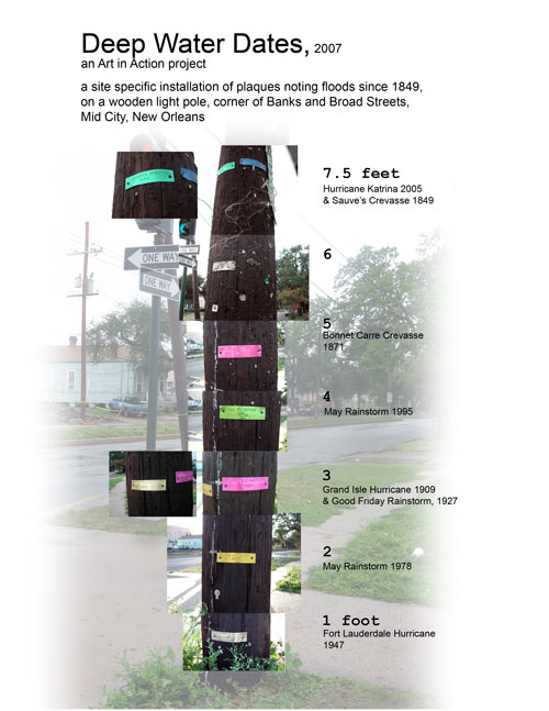
Eight anodized aluminum plaques with the name and date of a flood event are attached to a utility pole, marking the approximate height at which water flooded that location.
The plaques visually and physically represent flood depths throughout the recorded history in a specific area.
While visiting this busy corner, a viewer can sense the historical span of flooding while physically understanding the flood depths and the gravity of each event in relation to the human scale.
Deep Water Dates demonstrates the necessity for creating proper structures that ensure New Orleans’s future viability. The three centuries of recorded history in our strategically-placed city is packed with flood events that have caused our population strain and recurring devastation.
Deep Water Dates brings this history into the public eye and points to the constant battle our city has fought with nature for the gain of the nation. Here at the mouth of one of the world's great rivers (only 300 miles shorter than the Nile), our city balances precariously between human desire, corporate interests, and nature's forces. Our tenuous, and now severely compromised, geography has serious implications for the rest of the nation.
Installations of Deep Water Dates for 2-3 other New Orleans neighborhoods are in the works, as is a plan to travel a version of it to promote awareness.
Three main types of events cause flooding in New Orleans: levee breaches or crevasses, rainstorms, and hurricanes.
Sauve's Crevasse (a levee breach upriver) in 1849 is the first recorded flood that severely affected the newly-growing population in Mid-City, New Orleans. It is also the only flood that rivals Hurricane Katrina in flood depths.
On a visit to the Historic New Orleans Collection, I met with the encyclopedic John Magill, who told me a memorable tale about the Bonnet Carre river crevasse of 1871. A giant break in the levee upriver pushed so much water into the lake that the Hagan Avenue levee broke and flooded areas of the city that were populated then, such as Mid-City, for MONTHS. People resigned themselves to living in their flooded homes, on the 2nd stories or on top of furniture. Food and staples were delivered to them by boat. Like Katrina, this flood was also a media sensation, with reporters from all over the nation arriving in droves to chronicle the event.